Project information
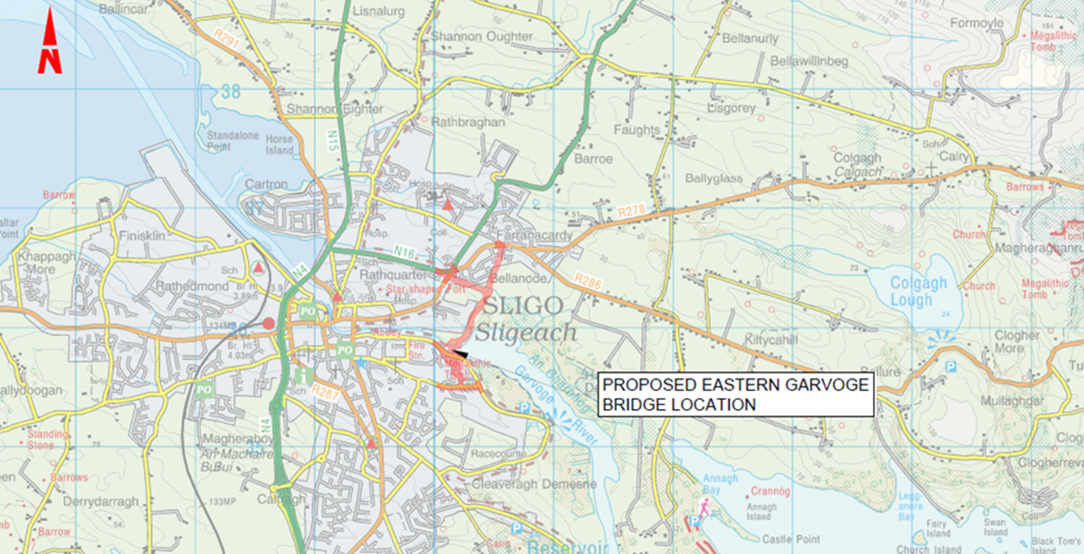
The proposed Eastern Garvoge Bridge and Approach Roads scheme will provide a new road link in a north south direction crossing the Garvoge River on the eastern side of Sligo City. The total length of the scheme is approximately 2.1km. Connection points with the existing road network were selected on the basis of dispersing traffic across the existing road network to ensure that the new link provides the desired improvement to connectivity within Sligo (See Figure 1 below).
 Figure 1 - Eastern Garvoge Bridge and Approach Roads Site Location (Source: Tailte Éireann)
The proposed scheme will include the following elements from north to south:
- Short Walk Junction. The existing junction which links Short Walk to the R286 Dromahair Road will be modified to receive a new arm for the Ballinode Link Road.
- Ballinode Link Road from the R286 Dromahair Road at the existing junction with Short Walk extending in a north-south direction over a length of 400m to the proposed Cushlough priority junction with the Northern Link Road and Cushlough Link Road, southeast of Glencarrig residential estate.
- Cushlough Link Road from the N16 Ash Lane Junction running parallel to the southern bank of the Cushlough River in an east-west direction over a length of 300m to the proposed Cushlough priority junction with the Northern Link Road and Ballinode Link Road, southeast of Glencarrig residential estate.
- Ash Lane Signalised Junction. The existing junction which links the N16 Ash Lane, N16 Manorhamilton Road, R286 Dromahair Road, and R286 Molloway Hill, will be reconfigured to facilitate a new arm for the Cushlough Link Road.
- Cushlough Priority Junction: a 3-armed junction connecting the Ballinode Link Road, the Cushlough Link Road and the northern approach road to the proposed Eastern Garvoge Bridge.
- A bridge over the Cushlough River for the Ballinode Link Road.
- Northern Approach Road extending for a length of 500m from the Cushlough Priority Junction to the Eastern Garvoge River Bridge through undeveloped lands at Rathquarter Hill and Ardaghowen House. This new road will skirt the edge of the Lough Gill Special Area for Conservation (SAC) and curve around the flanks of two small but prominent hills.
- Northern Garvoge Roundabout at the proposed Eastern Garvoge Bridge so as to facilitate a suitable road alignment for the Northern Approach Road around the side of the hill at Ardaghowen House.
- Eastern Garvoge Bridge over the Garvoge River with a link road between junctions on the northern and southern approach roads.
- Southern Garvoge Priority Junction: 3-armed Junction at Doorly Park / Garavogue Villas linking the proposed bridge to the Southern Approach Road and to Riverside.
- Realignment of Riverside over a length of 100m to connect to the Southern Garvoge Priority Junction.
- Southern Approach Road extending for a length of 270m in a north-south direction through a corridor between Doorly Park and Martin Savage Terrace. The initial third of this link will cross an open area of green space between the two housing estates, and the remainder will consist of widening of the existing access road that connects from Riverside to Cranmore Road.
- Road improvements and widening along Cranmore Road / Martin Savage Terrace for a length of 300m between the junction at Doorly Park / Cleveragh Drive at the eastern end and the Lidl supermarket at the western end.
- Provision of traffic signals at the existing junction of Cranmore Road / Martin Savage Terrace with Doorly Park / Martin Savage Terrace.
- Road improvements at the existing junction at the north-eastern end of Doorly Park Estate.

